Articles Posted in Uncategorized

Published on:

Every oil company lease form will contain a pooling clause, and the rights granted to the Lessee by that clause can significantly affect the economic and other rights of the Lessor under the lease.  Every Lessor should therefore understand the concept of pooling.

The basic idea behind pooling is a good one, and its use can benefit both parties to the lease.  In all states, laws and regulations have been adopted governing the spacing of wells – how many wells can be drilled in a field and how far apart they must be from each other and from the lease line on which the well is located.  These regulations have been developed to prevent the drilling of unnecessary wells and to maximize the ultimate recovery of oil and gas from a field.  The spacing rules — often called “field rules” — may differ from field to field, depending on whether the field produces gas or oil and on the geological characteristics of the reservoir.  In Texas, the Texas Railroad Commission’s spacing rules require an oil company to have a minimum number of acres under lease and assigned to a well in order for the Commission to grant a permit to drill the well.  The acreage assigned to the well is called a “proration unit”  (not to be confused with a pooled unit). For most oil fields, the proration unit size is 40 acres.  For gas wells, the proration unit size can range from 40 acres to 640 acres, depending on the field rules for that field. For horizontal wells, the amount of acreage that must be (or can be) assigned to a well generally depends on the length of the productive lateral. The longer the lateral the more acreage can be assigned to the well.

Where mineral ownership is divided into small tracts, it may not be possible for a Lessee to obtain a permit to drill a well unless it can somehow combine the small tracts into a larger tract for purposes of assigning a proration unit to the well.  For example, if the proration unit size in a field is 160 acres but all of the tracts in the field are 40 acres or less, then the Lessee must combine several tracts into a single unit in order to drill a well.  Also, the tract boundaries in a field may not fit the spacing pattern for a field.  The best location to drill a well may be exactly on the boundary between two tracts.  In such a case, the best solution is to combine all or parts of the two adjacent tracts to form a single unit.  This combining of acreage is called pooling, and the units so created are called pooled units.

Published on:

I recently ran across a publication containing two stories by O. Henry, purchased at the Capitol Visitors Center in Austin. The stories center on the Texas General Land Office, where O. Henry (then William Sydney Porter) worked as a draftsman between 1887 and 1891. The stories led me down a rabbit hole of the history of the Texas General Land Office.

The General Land Office is the oldest Texas state agency, established by the Republic of Texas in 1836 to “superintend, execute, and perform all acts touching or respecting the public lands of Texas.” When Texas entered the Union in 1845, the United States allowed it to keep its public lands rather than taking those lands in exchange for assuming Texas’ public debt. The GLO was responsible for granting patents as land was settled and sold. The history of land grants in Texas is complex and colorful, including Spanish and Mexican land grants in South Texas and to Stephen F. Austin and other empresarios who settled the land before Texas independence. The records of those Spanish and Mexican land grants, and all other grants and surveys of state lands, are housed in the General Land Office. Many of those records, including historical maps and surveys, have been digitized and can be viewed online at the GLO website.

After Texas won its independence from Mexico, Columbia became the nation’s capital and its archives were housed there. The records were moved to Houston when Congress declared Houston the capital of Texas in 1836. Then in 1839, then-President Mirabeau B. Lamar convinced Congress to authorize the establishment of a planned city, Austin, to be the nation’s capital, and the archives were moved there.

Published on:

I ran across a fascinating opinion from the 10th Circuit Court of Appeals that provides a window into Wyoming history. Iron Bar Holdings v. Cape, No. 23-8043, decided March 18.

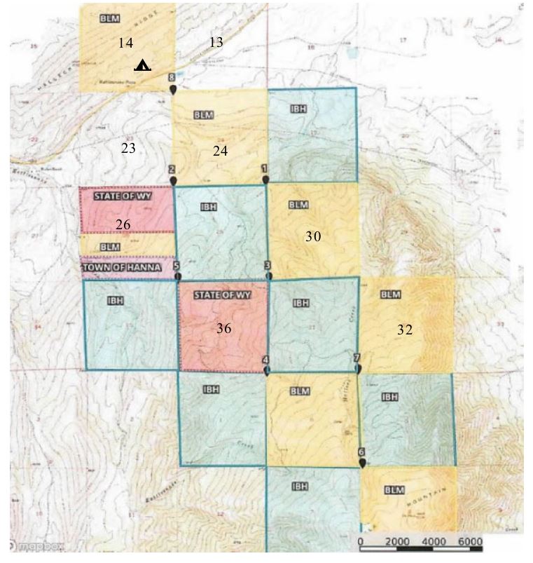
The facts are these: Iron Bar Holdings owns a ranch in southwest Wyoming covering 50 square miles. But within its boundaries are some 11,000 acres of federal and state public lands, some of which are completely enclosed by Iron Bar’s lands. In 2020, three hunters from Missouri decided to travel to Wyoming to hunt elk on public land within Iron Bar’s ranch. They could get to one section wholly surrounded by Iron Bar sections only by crossing over the corner touching two sections of federal land. So they stepped across the corner from Section 14 to Section 24, without setting foot on Section 13 or Section 23.

iron-bar-1As stated by the court, “Iron Bar is not friendly to corner-crossers.” It erected no trespassing signs at the corners, and its employees harassed the hunters. But in 2020 they did hunt on Section 24. They returned in 2021 to do the same, but this time Iron Bar convinced the local prosecuting attorney to prosecute the hunters for criminal trespass. They were acquitted in a jury trial. Not satisfied, Iron Bar sued the hunters for civil trespass, seeking $9 million in damages. It is this civil case that eventually ended up in the 10th Circuit.

Published on:

In Hamilton v. ConocoPhillips, the Corpus Christi Court of Appeals construed a Production Sharing Agreement – to my knowledge the first appellate court to do so.

A Production Sharing Agreement is an agreement between mineral owners and an operator to allow the operator to drill a horizontal well whose lateral will be located partly on the leased premises and partly on other lands. Generally, such agreements provide that the allocation will be based on the number of productive lateral feet of the well on each tract crossed by the well. If a well crosses Tract A and Tract B, and 60% of the productive lateral is on Tract A, then the parties agree that the royalty owners in Tract A will be paid royalty on 60% of the production from the well. Such an agreement is a form of combining multiple tracts to produce from a single well–essentially a form of pooling with a different method of allocation.

In Hamilton, Lloyd Hamilton owned a mineral interest in the original Hamilton Ranch in DeWitt County, covering some 5,000 acres, which the Hamilton family leased to Burlington Resources Oil & Gas (now a subsidiary of ConocoPhillips). After the lease was signed the family partitioned the land and Lloyd received a separate surface tract, subject to the lease. The family then signed a Production Sharing Agreement allowing Burlington to drill wells located partly on the Ranch.

Contact Information